


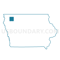
ARCHER Voting District, O'Brien County, Iowa
About
Outline

Summary
| Unique Area Identifier | 582951 |
| Name | ARCHER Voting District |
| County | O'Brien County |
| State | Iowa |
| Area (square miles) | 0.09 |
| Land Area (square miles) | 0.09 |
| Water Area (square miles) | 0.00 |
| % of Land Area | 100.00 |
| % of Water Area | 0.00 |
| Latitude of the Internal Point | 43.11510430 |
| Longtitude of the Internal Point | -95.74409950 |
Maps

Graphs
Select a template below for downloading or customizing gragh for ARCHER Voting District, O'Brien County, Iowa


Neighbors
Neighoring Voting District (by Name) Neighboring Voting District on the Map
- CARROLL TWP W/O ARCHER & SHELDON Voting District, O'Brien County, IA
- SUMMIT TWP W/O ARCHER & PRIMGHAR Voting District, O'Brien County, IA